The first major snowstorm of the unofficial winter season has eyes for Schuylkill County.
It’s already got a name: Winter Storm Ezekiel.
We’re tracking the latest on the first big storm of the 2019-20 winter season. Check back here for updates as we get closer to the start of the storm.
Winter Storm Ezekiel Live Updates
Here’s what some of the top weather teams in the coal region are saying about Winter Storm Ezekiel, whether they call it that or not. The Canary is on the ground tracking the panic on the streets about the upcoming storm. We’ll be monitoring any ice melt shortages and people bitching about parking as the storm hits the area.
Don’t forget to check The Canary’s increasingly popular Twitter feed, too. @HardCoalCanary
Sunday, December 1
After the morning glaze of ice and subsequent rain, that brief lull forecasters promised did happen. Round 2 of Winter Storm Ezekiel started just before 10 p.m. and saw a moderate downfall of freezing rain and sleet over Pottsville.
What happens next though, is anyone’s guess at this point.
We do know that the National Weather Service extended the Winter Weather Advisory for Schuylkill County until 1 p.m. Monday.
Here’s a look at some of the other leading forecasts around the coal region:
Fannock Says 5-10″
Our latest update required its own post but we had to add it to our Live Panic Post for Winter Storm Ezekiel.
Local forecaster Ryan Fannock says Round 2 from Winter Storm Ezekiel could bring Schuylkill County up to 10″ of snow through Monday.
3 Shades of Schuylkill
WNEP’s backup quarterback of a weather guy, Kevin Derk, showed off a map during the 10 p.m. newscast that shows Schuylkill County getting 3 different variations of this storm.
If you live in Pine Grove and other points on the western side of Schuylkill County, you can probably only expect 1-3″ and a lot of slush. That line extends into Pottsville (making the forecast from Accuweather below a little vexing). Just to the northwest and southeast of Pottsville, though, they might get between 3-6″ of snow. And Derk thinks places in the north and east of Schuylkill County could get between 6-12″ of snow before Ezekiel finally spins out of here.
So, let’s see what the others are saying:
Accuweather’s Snowfall Map for Schuylkill County
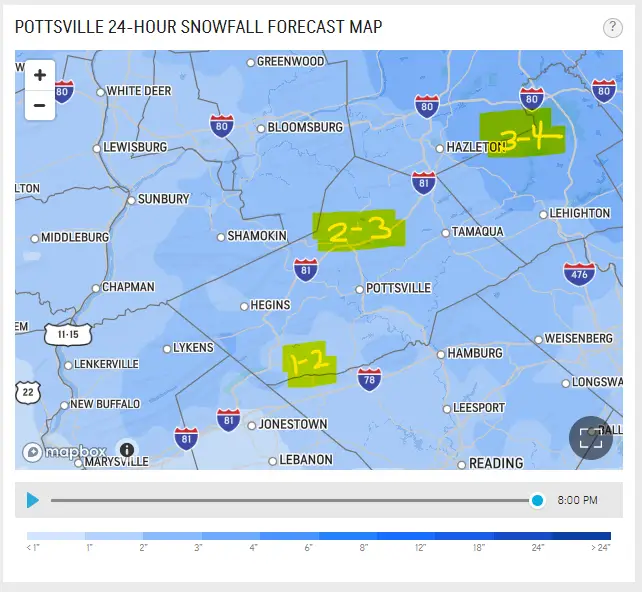
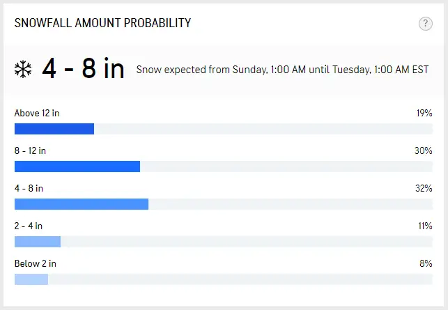
4-8″ of Snow Sunday Into Monday?
Check out this “Snowfall Amount Probability” chart put together by Accuweather. Seems a bit off or maybe Accuweather is covering its bases on the Pottsville forecast:
The Weather Channel Puts Schuylkill County in the 3-8″ Range
Here’s The Weather Channel’s map for the projected snowfall through Monday.
Most of Schuylkill County would be in the light purple.
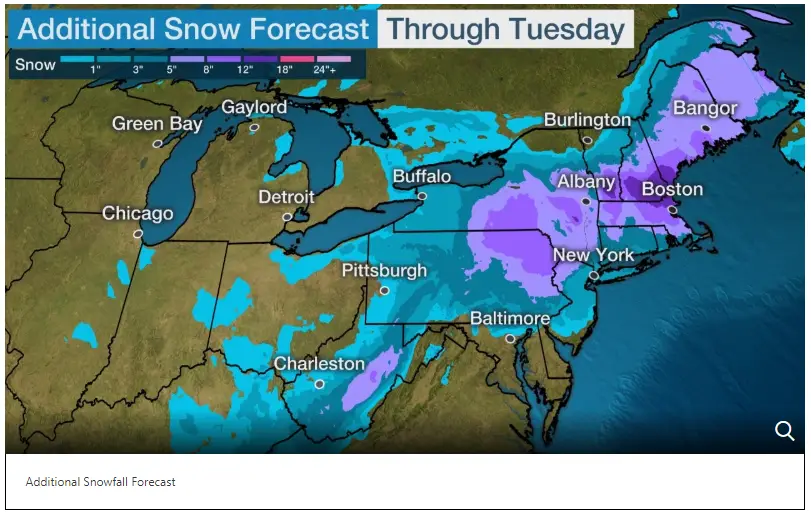
On the 36-hour forecast, The Weather Channel predicts 3-5″ of snow for Pottsville.
AFTERNOON UPDATE
Ice Glazes Pottsville
Winter Storm Ezekiel finally arrived but a lot like the Michael’s at Fairlane Village Mall, it’s a lot smaller than expected.
You probably woke up to a small glaze of ice on your cars and sidewalks across Pottsville Sunday morning. Couple that with a quick burst of moderate freezing rain, sleet, and snow and roads across the area went from OK to very slick in a matter of minutes.
NWS still has Schuylkill County under a Winter Weather Advisory for the duration of the two-part winter storm. Temperatures should rise through the afternoon and any freezing precip falling will change to rain. Then, another brief lull in activity will resume again as light snow. About 1″ is still predicted around Pottsville.
Winter Weather Advisory – Schuylkill County – Little Ice, 1″ of Snow
LIVE – Schuylkill County Weather Radar
- Only in the Coal Region – Using Ashes for Ice Traction
Saturday, November 30
Saturday Evening Update
National Weather Service Predicts Limited Impact Over Pottsville
It’s looking like the big storm everyone was excited for may be fizzling out before it gets here.
In a recent update from NWS-State College, forecasters see “limited impacts” from the storm they don’t call Winter Storm Ezekiel. That covers most of Schuylkill County. But there is a chance that the north and east sections of Schuylkill County do get hit harder with the wintry weather.
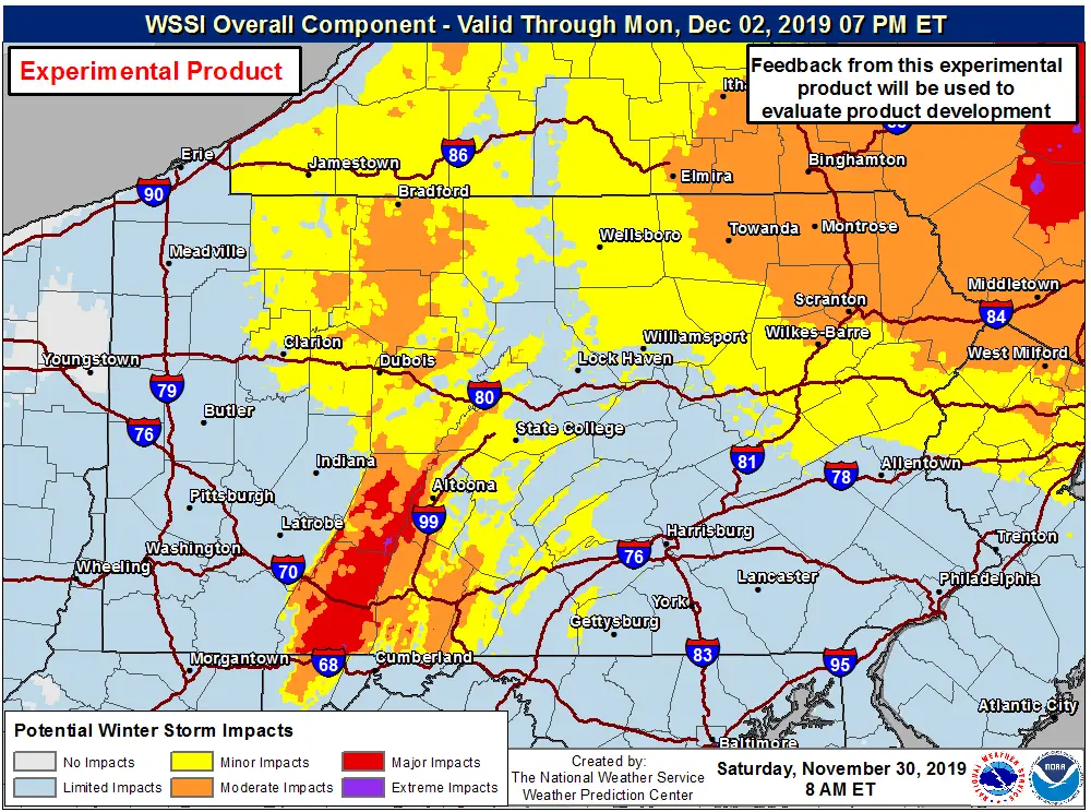
(Image: NWS)
Keep in mind, as they so plainly put it, that map is an “experimental product” and apparently they’re going to see if it catches on amid the weather panic.
And at about 6 p.m., NWS issued this guidance for the storm’s start time:
Here’s an updated map of start times for the wintry mix moving in. Sleet, snow, and freezing rain will start in the Laurel Highlands before midnight and expand northeastward through central PA overnight and in the predawn hours. #PAwx pic.twitter.com/UFka0ljKKJ
— NWS State College (@NWSStateCollege) November 30, 2019
Looks like the first band of wintry weather — the part that’s supposed to bring us the icy conditions before changing to rain — will get underway around 7 a.m. Sunday.
Now, even though they’re predicting a little less accumulating snow for Schuylkill County, NWS still predicts 2-4″ of snow in the second band of weather, the coastal part of the storm. It just seems we’re more likely to get the 2 rather than the 4 at this point.
Rayno Stuck on 3-6″ of Snow for Schuylkill County
Accuweather’s Bernie Rayno still had Schuylkill County in the 3-6″ range about 8 hours ago (11 a.m. Saturday).
Check out his live update from late Saturday morning:
Fresh injection, strong warm advection, upper low leads to Snowstorm https://t.co/Y7a33eh3Pk
— Bernie Rayno (@AccuRayno) November 30, 2019
***
Late Night (Friday) Update
We’ve got a wrap-up of a lot of weather trackers keeping their eyes on Winter Storm Ezekiel.
WBRE/WYOU Sitting On the Saturday Fence
WBRE/WYOU-TV says it’ll have a snow total map on Saturday. It seems odd that news stations that rely on either NWS or Accuweather forecasts for their own weather (and pay good money to be associated with one of those, in particular) are afraid to make a snow total forecast.
Could this all be setting up for a last-minute bust?
If You’re Into Timelines for Weather Forecasts …
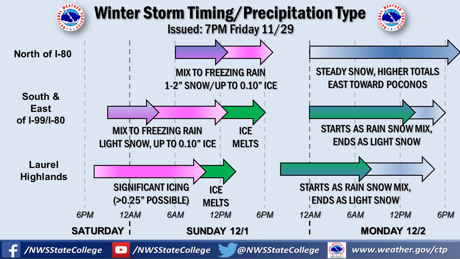
National Weather Service tried to break down the storm by region using this timeline chart. It shows the storm in two parts and details what to expect depending on the region you call home.
(Image: National Weather Service)
The Weather Channel Brings Some Rain to the Forecast
During the first part of the Sunday-Monday storm, Ezekiel, The Weather Channel indicates the wintry mix that is the first part of the storm could end as rain in Pottsville. Overall, they predict 1-3″ of snow during the first part of the storm. They’re calling for another 2″ of snow in the second half of the storm
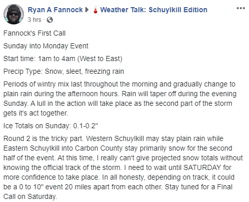
Fannock’s First Call? Wait for the Final Call.
Ryan Fannock wasn’t ready to make a snowfall prediction as he’d hoped on Friday night.
He posted this message across Facebook to the thousands of people who follow his forecasts:
Rayno Says “Foot of Snow” … For Albany, NY – 3-6″ Here in Schuylkill County
Accuweather’s Bernie Rayno gave an update on the winter storm from his mom’s house in Beaver Meadows, PA. In this 17-minute Periscope stream, he says Schuylkill County could get 3-6″ of snow. But in Berks County, just 1-3″, so the line is close to us here in the coal region. At the same time, parts of Northeast PA could get 6-12″ of snow.
“Get where you need to go Saturday night,” he says.
Northeast snowstorm with over a foot of snow coming https://t.co/HPSU2MCRIX
— Bernie Rayno (@AccuRayno) November 29, 2019
Bastardi Shows EURO Model at 4-6″ in Schuylkill County
Joe Bastardi shared one of the latest EURO model runs showing about 4-6″ of snow across most of Schuylkill County.
Big ticket Noreaster coming, Euro snow amounts, max gusts. pic.twitter.com/Dr61dlRMzW
— Joe Bastardi (@BigJoeBastardi) November 29, 2019
Friday, November 29
More than 24 hours away from the expected start of “Winter Storm Ezekiel” and some forecasters seem to agree that 6″ of snow is the limit for the Pottsville area. Add in about one-tenth inch of ice also predicted. Others, however, are willing to wait before making a call …
7:19 p.m. | WNEP’s Scott Stuccio Says “Way too early for numbers, gang”
During the 7 p.m. newscast on WNEP-TV, meteorologist Scott Stuccio predicted “a mess on its way” but says it’s “way too early for numbers, gang.”
Rayno Promises More Thorough, Longer Forecast
Sounds kinda weird, but OK:
Will be posting another video tonight . This will be much more thorough and longer
— Bernie Rayno (@AccuRayno) November 29, 2019
5:33 p.m. | WBRE/WYOU Says “Too Early” for Snowfall Totals
In an early evening update at PAhompage.com, WBRE/WYOU meteorologist Logan Westrope says, “It’s still a little too early to pinpoint exact snow amounts, but accumulating snow is possible at this point.”
Sometime between these updates | Fannock Says First Call at 9
Viral weather forecaster Ryan Fannock says he’s ready to make his first call at 9 p.m. Friday.
Earlier in the day, Fannock shared an early run of the EURO model that has the storm bringing between 6-9 inches of snow to the heart of the coal region.
2:17 p.m. | NWS Issues Winter Storm Watch
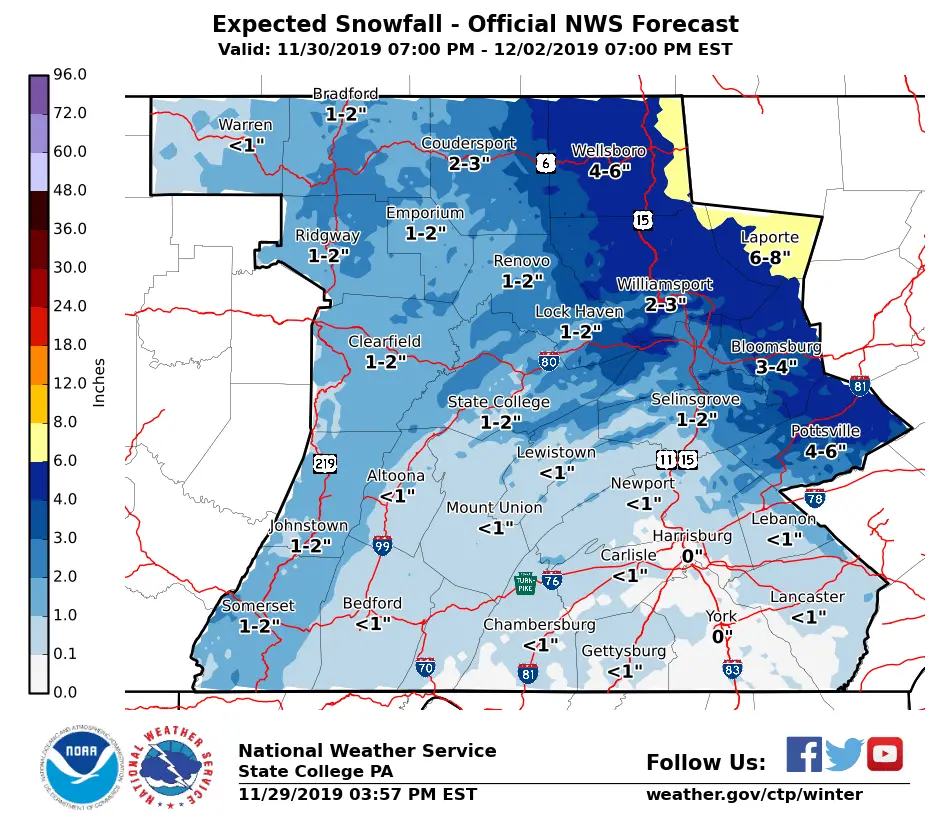
National Weather Service issued a Winter Storm Watch for Schuylkill County from Sunday at 1 a.m. until Monday at 7 a.m. The predicted snowfall total in Pottsville is 4-6″. Places north and east of the city will get more snow.
(Image: National Weather Service)
1:26 p.m. | Accuweather’s Bernie Rayno Puts Schuylkill County in 3-6″ Range
In a live Periscope video, Accuweather’s Bernie Rayno (a Northeast PA native) predicts between 3-6″ of snow
Northeast snowstorm https://t.co/yZhAzNilQr
— Bernie Rayno (@AccuRayno) November 29, 2019
Subscribe to Coal Region Canary
Get email updates from Coal Region Canary by becoming a subscriber today. Just enter your email address below to get started!Support Coal Region Canary
Like our reporting and want to support truly local news in Schuylkill County? Your small donations help. For as little as $5, your contribution will allow us to cover more news that directly affects you. Consider donating today by hitting the big yellow button below ...


