


Weather forecasters seem unwilling to commit to details on the potential for snow this weekend in Schuylkill County.
However, as we move through the day on Friday, it appears something will likely happen with regard to a snowstorm on Sunday.
Just how much it will actually snow is … up in the air right now.
Let’s have a look at what National Weather Service and the more popular and most-often cited weather models are showing for the potential snowstorm this weekend in Schuylkill County.
Snow Forecast for Schuylkill County – Sunday, Feb. 22
Overnight, National Weather Service became more convinced that snow is definitely on its way here. Even our early morning forecast shows very little in the way of snow accumulations.
But as of late Friday morning, the totals have been boosted a bit.
Just how much snow is expected, based on this most recent forecast, really depends on where you live in Schuylkill County.
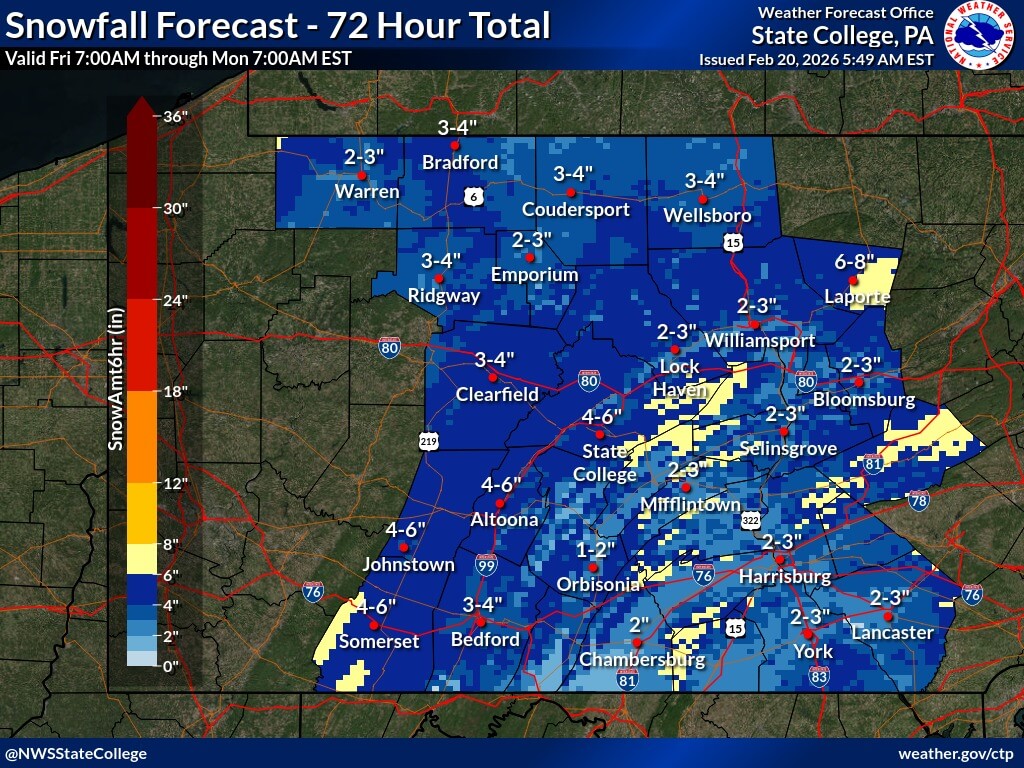
For places to the west, like Pine Grove, National Weather Service is calling for 2-5 inches of snow on Sunday with a chance of lingering snow showers into Monday.
In the big city of Pottsville, the forecast has slightly more snow potential, between 2-6 inches.
Up north, in a spot like McAdoo, NWS has 3-7 inches falling on Sunday. Mahanoy City is forecast to get between 4-8 inches.
And in the east, locations like Tamaqua could get between 3-7 inches of snow.
Here is a snowfall map National Weather Service released Friday morning showing potential accumulations. Even this map is a bit all over the place, with between 2-8 inches randomly splashed across the area:
We’ll have our town-by-town snow totals charts available a little closer to the potential storm.
Weather Models Say Snow, Disagree on Severity
From people who follow weather models more closely than us casual observers, they say to not rely on snow totals in weather models, especially this far away from a potential snowstorm.
OK, so let’s just look at these models to determine the severity of a potential storm this weekend in Schuylkill County.
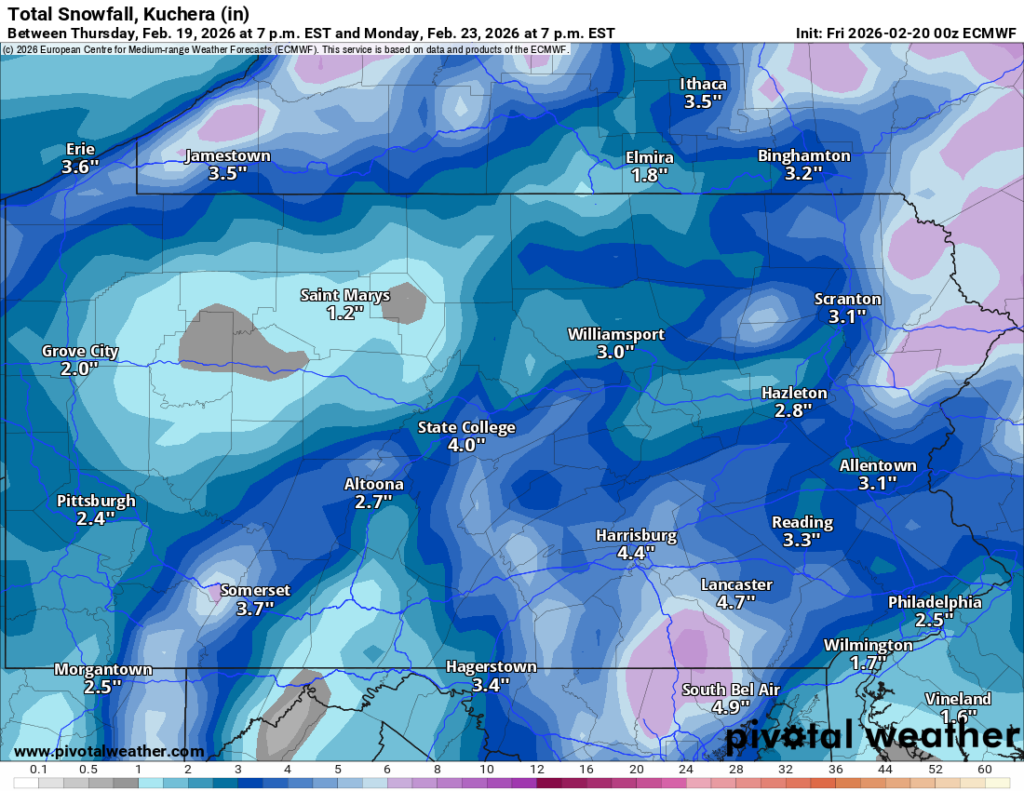
Euro
The European model is one of the more conservative forecasts on snow potential this weekend.
Again, not to rely too heavily on the actual snow totals but in this latest run of the European model, are looking at up to 5 inches of snow in portions of Schuylkill County, with the least in extreme northern areas.
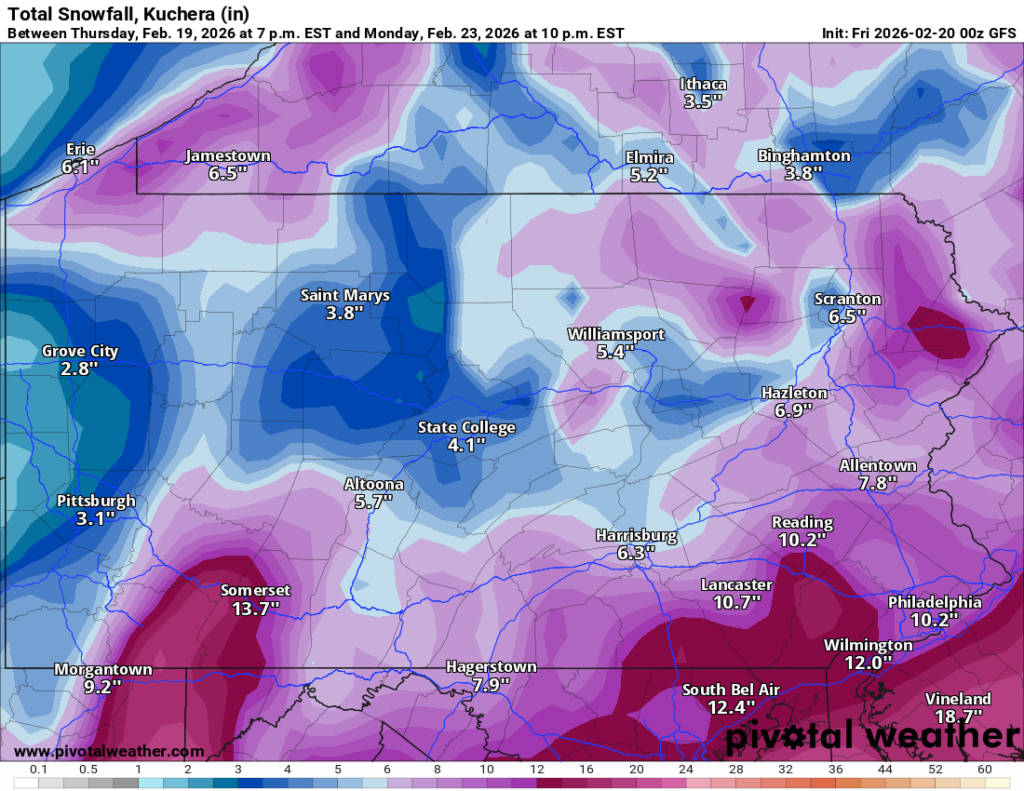
American
The American model is showing the higher end of snow totals forecast by National Weather Service. It’s important to note that the snow totals on this model in its latest run are noticeably less than they were just 12 hours ago.
But it’s still enough to ruin the end of your weekend and early part of the day on Monday.
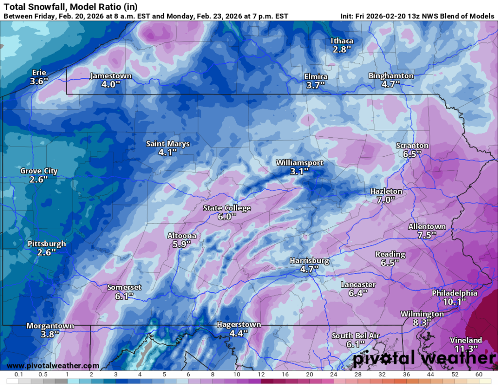
NWS Blend of Models
The weather forecasts you see daily on Coal Region Canary come right from the National Weather Service. So, here’s a look at the NWS Blend of Models and the forecasted snowfall for this weekend.
You’ll see here, as of the latest complete run, it’s also on the high end of the snow totals available in local forecasts.
The Latest on the Snow in Schuylkill County
As is the case with every storm, we’ll update forecasts as often as is warranted ahead of the storm. If and when alerts are issued, we’ll share those right away, too.
Pingback: Winter Storm Watch Issued for Schuylkill County - Coal Region Canary