


The latest update from National Weather Service (as of 1:30 p.m.) shows lower snow totals for Schuylkill County.
Forecasters now believe the storm will track more to the east but there will likely be enough snow to cause travel troubles for many tonight into Monday.
A Winter Storm Warning remains in effect for Schuylkill County. NWS now says anywhere between 3-8 inches is expected across the area.
Wind gusts of up to 35 mph tonight and 40 mph on Monday are still expected.
Here’s a look at the latest snowfall totals for Schuylkill County, based on the 1:30 p.m. update:
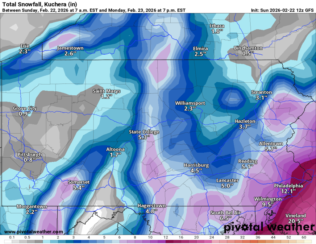
American
The latest GFS run shows slightly lower snow totals in Schuylkill County than it did in a previous run.
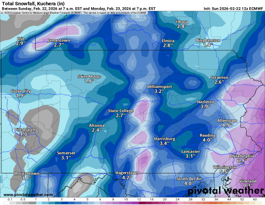
Euro
The Euro model remains conservative with snow totals in its latest run.
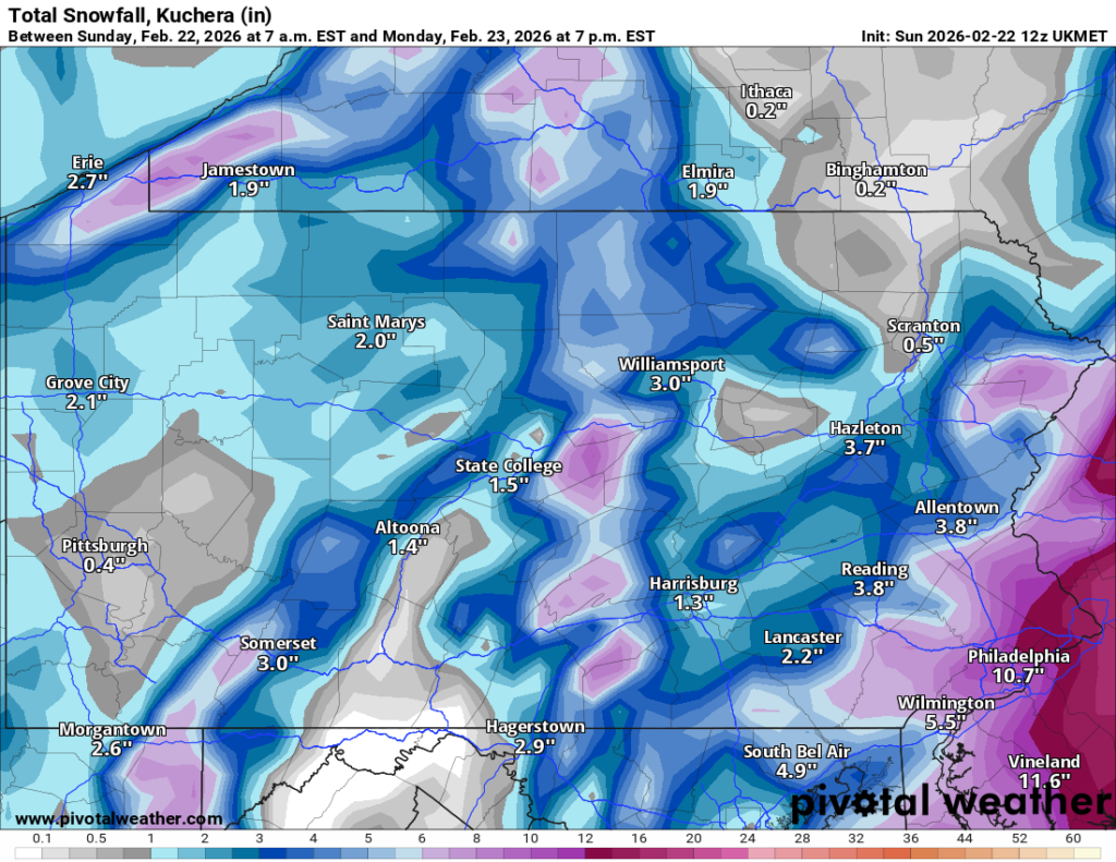
UK
The UK model shows between 2-4 inches of snow over Schuylkill County.
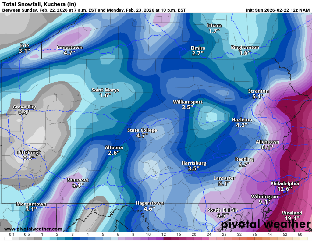
NAM
This short-range model has come way off its previous run with snow totals in Schuylkill County and is more in line with others now.
HRRR
Another short-range model, the HRRR, still shows the most snow for Schuylkill County, but considerably less than previous runs.

National Weather Service Forecast – Storm Timing
The timing of this storm largely remains the same. It’s just the intensity of the snow that’s really changed, with totals about half of what was forecast this morning.
Latest Snow Totals for Schuylkill County on Feb. 22-23
Here are the latest snow totals forecast by National Weather Service for numerous locations around Schuylkill County (as of 1:30 p.m. Sunday). If you’re looking at these totals against the model runs we’re showing here, you may want to look at the lower number in the forecast over the higher total:
| Location | Snow |
|---|---|
| Andreas | 5-10" |
| Ashland | 3-7" |
| Auburn | 3-7" |
| Barnesville | 6-13" |
| Coaldale | 5-11" |
| Cressona | 4-6" |
| Deer Lake | 4-8" |
| Delano | 8-16" |
| Deturksville | 3-5" |
| Frackville | 4-10" |
| Friedensburg | 3-5" |
| Gilberton | 4-10" |
| Girardville | 4-10" |
| Good Spring | 4-7" |
| Gordon | 4-8" |
| Hegins | 3-5" |
| Hometown | 6-13" |
| Klingerstown | 3-5" |
| Lake Wynonah | 4-8" |
| Landingville | 4-8" |
| Lavelle | 3-5" |
| Mahanoy City | 7-15" |
| McAdoo | 8-16" |
| Middleport | 4-9" |
| Minersville | 4-6" |
| Muir | 4-6" |
| New Philadelphia | 4-9" |
| New Ringgold | 5-10" |
| Orwigsburg | 4-8" |
| Palo Alto | 4-7" |
| Pine Grove | 3-5" |
| Pitman | 3-5" |
| Port Carbon | 4-7" |
| Port Clinton | 3-7" |
| Pottsville | 4-7" |
| Ravine | 3-5" |
| Ringtown | 4-8" |
| Rock | 3-5" |
| Sacramento | 3-5" |
| Saint Clair | 4-7" |
| Schuylkill Haven | 4-8" |
| Shenandoah | 6-12" |
| Sheppton | 7-15" |
| South Tamaqua | 5-10" |
| Suedberg | 2-5" |
| Tamaqua | 5-10" |
| Tower City | 4-6" |
| Tremont | 3-5" |
| Zion Grove | 5-10" |
STORM CENTER HEADLINES:
- Pottsville to Implement Level 2 Snow Emergency Parking Restrictions
- STORM CENTER: Schuylkill County Winter Storm Alerts