Hope you enjoyed this weekend’s balmy weather.
You may really be missing it by this time next week.
One local weather forecaster thinks Schuylkill County could be in line for its first major snowstorm of the season.
And he’s putting up some whopper snow totals.
Big Snowstorm for Schuylkill County?
Local weather forecaster Ryan Fannock posted a long-range forecast on his popular FannockWeather.org site Saturday night. Right now, he’s predicting snow to move into the Schuylkill County area by Friday night, January 17.
And then even more snow on Saturday. His brief forecast indicates “Moderate to heavy accumulations possible.”
The storm he’s predicting right now would end Saturday night.
In addition to the snow, he’s also predicting some really cold air to move in after the storm. He’s only predicting a high of 22 on Sunday with a low of 9. Wind chills could dip to -10. That Arctic air would have a grip on the coal region following the storm. Highs for next Monday, the 20th, are 13 degrees, with a low of 3. Tuesday, the 21st, is predicted as another cold day: a high of 17 and a low of 15.
That wasn’t enough information for us, so we went to his Facebook group, Weather Talk: Schuylkill Edition, to learn more.
Now, and Fannock notes this fact too, this is a long-range forecast. We’re talking 5-10 days away here.
So, the snow map he posted on Saturday evening is a long look into the future. The Arctic blast he’s predicting is even longer down the road.
However, Fannock was sure to remind everyone Saturday that he predicted this weekend’s Spring-like feel well in advance, too.
Schuylkill Snow Total Forecast – January 17-18 Storm
Fannock knows a lot of readers are hoping for a big storm. He also knows a lot of people are going to complain about a big storm.
Either way, it’s Likes and Angry faces and clicks through to his website and return visits until the storm gets here.
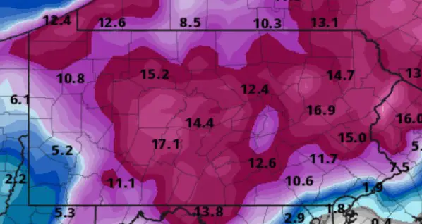
So, he posted a map that shows some monster snow totals for Schuylkill County next weekend.
In fact, some portions of Schuylkill County could get more snow next weekend than any other part of the state. And overall, we could get hit with the worst part of the storm.
He wrote Saturday on his Facebook group, “I just can’t resist posting the latest Canadian run for all the snow lovers out there. This would be total snowfall from the storm on the 18th.”
Remember, these are long range numbers from one particular weather model.
He’s just putting this number out there to whet your whistle.
Just to get you ready … it’s a big one.

“For God’s sake, just give me the damn number!”
Fannock reminds us, before you see this map, “As always, these numbers can and will change. They may go up, they may go down and it could end up being a mix. We all know how PA weather can be fickle. But nonetheless, here’s some eye candy!”
So, here’s the map he posted.
The numbers are inches of snow …
(Image: Fannockweather.org)
For places like Shenandoah and Mahanoy City, you could be in line for up to 17 inches of snow!
In the Pottsville, Cressona, Schuylkill Haven, and Tamaqua areas, we’re looking at about 15 inches of snow.
And for the west and south of Schuylkill County, places from Tremont and Pine Grove to Orwigsburg and Deer Lake, it’s looking like a foot of snow could be in your future.
What Others are Saying
We think it’s fun to start freaking out about a potentially big snow storm as soon as possible. Drop even the slightest hint of a big storm and we’re on it.
But we did some research to see what others are saying right now about the potential for a big storm next weekend.
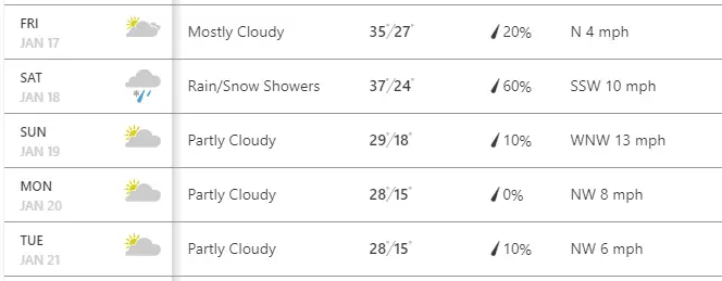
As of Sunday morning, The Weather Channel has Schuylkill County in line for some rain and snow showers next Saturday and then some temps not as frigid as Fannock predicts.
Here’s a look at part of their 10-day forecast for Pottsville:
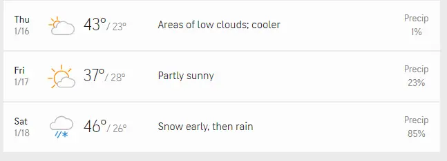
Accuweather is on the same page as The Weather Channel, for the most part. They’re predicting some warmer weather for Schuylkill County to continue into this week, including Saturday.
You can see in this long-range forecast, they’ve got us getting snow then rain on Saturday.
It seems the one thing everyone agrees on right now is that it’s going to do something on Saturday. Just what and how much still seems to be … up in the air.
Better stay tuned to see how this develops over the next few days.
CHECK OUT THE UPDATED FORECAST FOR THIS STORM:
Subscribe to Coal Region Canary
Get email updates from Coal Region Canary by becoming a subscriber today. Just enter your email address below to get started!Support Coal Region Canary
Like our reporting and want to support truly local news in Schuylkill County? Your small donations help. For as little as $5, your contribution will allow us to cover more news that directly affects you. Consider donating today by hitting the big yellow button below ...














Stanley Bokunewicz
January 14, 2020 at 8:35 am
Nice forecast for Shenandoah we get more on the heights because we are closer to Heaven