


You could ask a handful of meteorologists the weather model they trust the most and you’ll get a handful of different answers.
We’ve got no skin in the game but we do have a commercial subscription to PivotalWeather.com, so we like to share images of all these models and then play Monday Morning Quarterback after a snowstorm to see which one was most accurate. (Also, the traffic we get on sharing these model images helps offset the cost of that one particular subscription.)
So, with this next snowstorm apparently having Schuylkill County in its crosshairs, we want to see which one is truly on the money when it comes to accurately forecasting the snow totals we’ll eventually see.
Officially, National Weather Service has Schuylkill County under a Winter Storm Warning from Midnight until 1 p.m. on Tuesday, Feb. 13. Forecasters there are predicting anywhere between 6-12 inches of snow for Pottsville. But on its general warning update, it’s predicting between 5-9 inches for the area.
Now, that total has changed drastically over the course of the last few days. In fact, before bed time Sunday night, the NWS forecast had some sleet and rain and about 1-3 inches of snow for us here in Pottsville, with slightly higher amounts north of us, like in places such as Shenandoah and Frackville.
And if you read our previous post on the latest weather models, you saw that the forecasts weren’t in line with the models. There’s still some debate, it seems, on whether this will be a rain, sleet, and snow event that keeps snow totals down or it turns into a real whopper of a snowstorm.
The Latest Weather Models for Schuylkill County on February 12-13
So, after looking at 4 of the most talked about weather models (the GFS, Euro, NAM, and HRRR), it seems there’s almost 100% agreement that a rather significant snowstorm is about to wallop us here in Schuylkill County.
If you didn’t get your bread and milk, we can’t help ya.
However, there is one outlier. There’s one model that just doesn’t see what the others are apparently seeing. And that’s the Euro, or the ECMWF.
Let’s have a look at the snow totals each of the popular models is showing for us here in the coal region.
GFS – Monday 18z
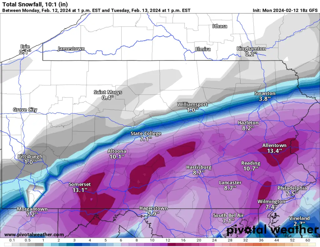
We can tell you that the GFS model is showing snow totals between 9-12 inches for Schuylkill County. Most of the county gets at least 10 inches if this model is accurate.
Euro – Monday 12z
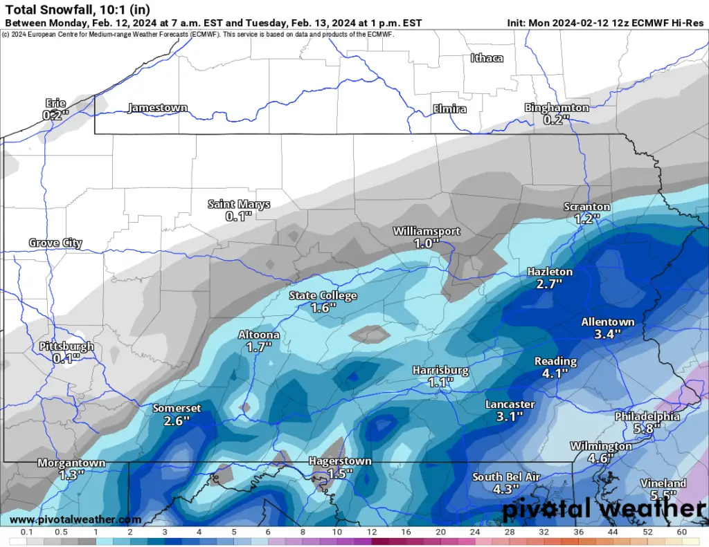
The Euro model looks like it’s behind the times with its snowfall predictions, putting 2-4 inches of snow on us here in Schuylkill County.
The reason? It’s showing a longer period of rain on Monday night and then that rain mixing with some freezing precipitation before changing to all snow on Tuesday.
NAM – Monday 18z
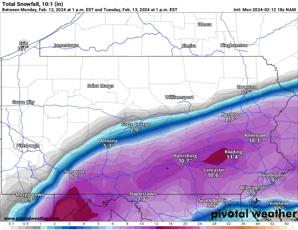
The NAM is actually showing something a little different in terms of where the heaviest snow will fall on Schuylkill County. It’s still putting quite a bit on snow on us, but the heaviest totals would be in extreme southern Schuylkill, where they can expect a foot of snow.
HRRR – 18z
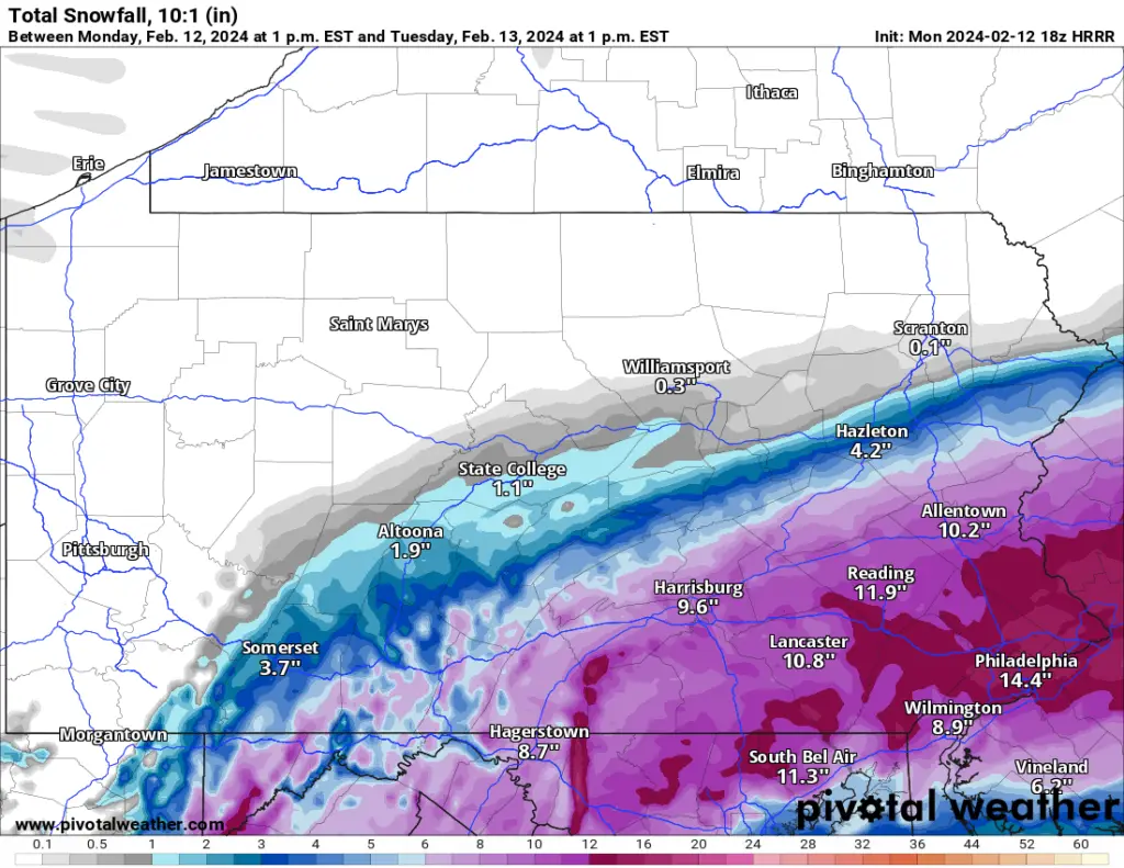
The HRRR model is also showing that trend happening, with the storm pushing out to see on a more southerly path. This puts only 2-3 inches in extreme northern Schuylkill County but 10 inches along our southern border.
We fully expect this storm forecast to change right up to and probably while it starts doing whatever it is it’s going to do.