Many of the top weather models have amped up their snowfall total forecasts for Schuylkill County ahead of the January 6-7 storm.
Some of these models have the area getting close to a foot of snow, based on our observations. And none of them have anywhere in Schuylkill County getting less than 6-7 inches of snow from this weekend’s expected storm.
And unlike our report from Thursday morning, the models are more closely aligned with only slight differences in snow totals.
Weather forecasters, though … either they’re not totally buying into the hype or they just haven’t caught up with the latest information.
As always, we will take a look at the weather model images as well as what some of the more popular forecasters are saying about this storm, as of 1 a.m. Friday, Jan. 5.
January 6th Winter Storm Timing
First, we’ll take a look at the quick facts on the storm, as they’re being reported.
- BEGINNING: After 1 p.m. on Saturday, January 6
- ENDING: Early morning hours of Sunday, January 7
- WINTER STORM WATCH: National Weather Serviced placed Schuylkill County on a Winter Storm Watch beginning Saturday morning and extending into Sunday morning.
- MORE: National Weather Service says travel conditions could be hazardous starting on Saturday afternoon and downright treacherous on Saturday night. Regardless, everyone is predicting a rather fast-moving storm with heavy accumulation in a short time frame from the evening into the night on Saturday.
- TIMING: Snow will be heaviest on Saturday night, especially before 1 a.m. Sunday. That means waking up to potentially a lot of work to get your sidewalks cleared and vehicle shoveled out.
- RAIN/SNOW?: There are more hints than yesterday that a wintry mix could accompany this snowstorm. It’ll all depend on the final track of the storm as it reaches us here in Schuylkill County. Any mixing of the precipitation will obviously lower any predicted snowfall totals.
Weather Models Now Showing Schuylkill County Getting 7-12 Inches of Snow
OK, now let’s look at the Friday 00z runs of 4 of the popular weather models to show what they have falling on Schuylkill County in terms of snow accumulation through Sunday afternoon.
As we’ve already noted, these snow totals shown on the following maps are generally higher than they were on our Thursday update.
Fair warning: These can and likely will change through the day on Friday and even early Saturday. So, take these maps into consideration but treating them as gospel at this point would be short-sighted of you.
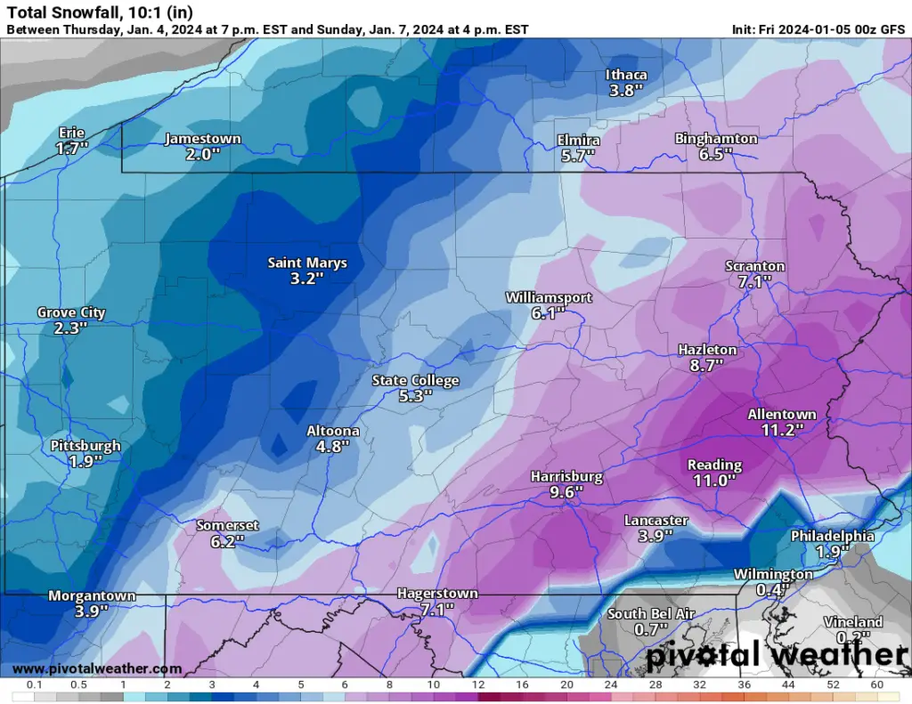
GFS – Friday 00z (Thursday 7 p.m.)
This latest run of the GFS model shows an increase in snowfall totals for Schuylkill County when compared to the same model 24 hours ago.
If this model holds true, Schuylkill County could get anywhere between 8-11 inches of snow, with the highest totals falling in the extreme south and east of the area.
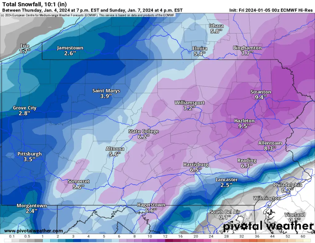
Euro – Friday 00z (Thursday 7 p.m.)
This Euro model run also shows a significant snow event here in Schuylkill County, with totals ranging from 7-9 inches.
However, the highest totals on this map are in the extreme north of the county and slightly less in the west.
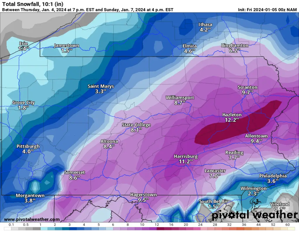
NAM – Friday 00z (Thursday 7 p.m.)
On Thursday at this time, the NAM model was showing the least amount of snow among the ones were tracking for Schuylkill County.
This latest run is the complete opposite. In fact, this run shows a large swath of Schuylkill County getting a foot of snow from this storm through Sunday afternoon. The only exceptions would be a small patch of the county in the extreme north and the southern border of the county, which would get 11 inches.
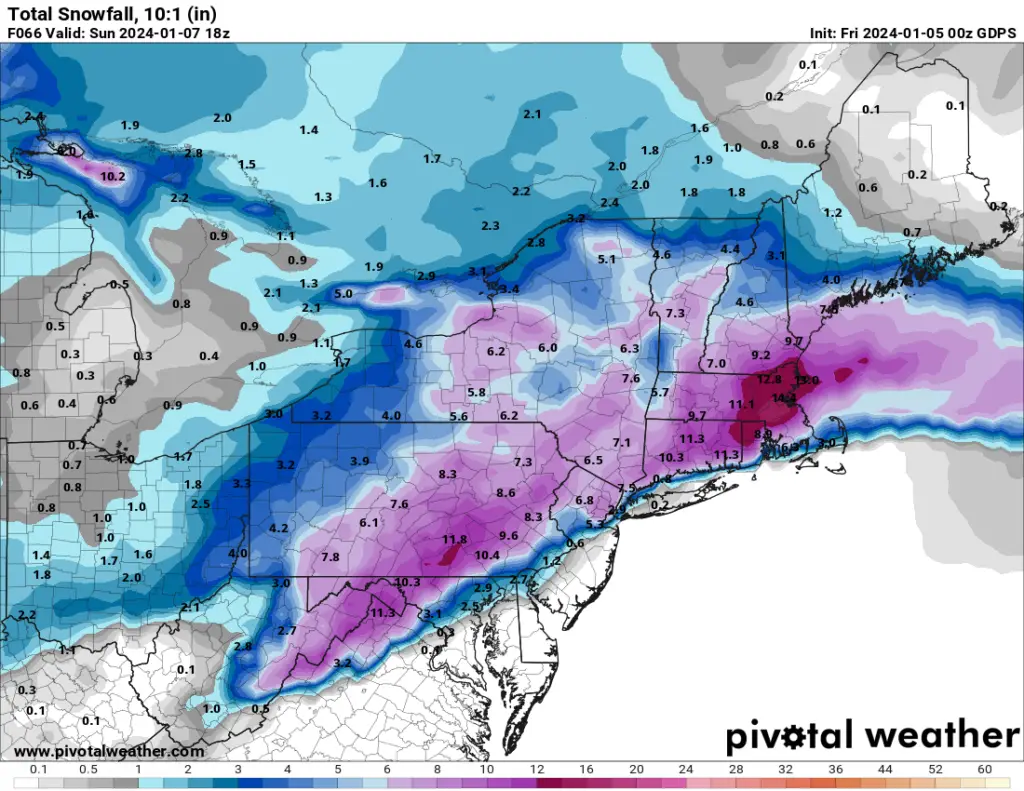
Canadian – Friday 00z (Thursday 7 p.m.)
This Canadian model also amped up the snow totals for Schuylkill County in the last 24 hours. It, too, was rather low when we reported on it a day ago. Now, it’s closer to what the NAM is showing, with Schuylkill County getting close to a foot of snow.
Forecasts Either Not Up-to-Date or Aren’t Buying Into the Models Just Yet
The people who get paid to read these models and make their snowfall predictions aren’t completely buying into the highest of the high snowfall totals, at least not yet.
Here is a roundup of the top forecasting sources and what they believe will happen with this snowstorm:
National Weather Service
Of all the forecasts out there right now, National Weather Service is low-balling the snow totals for Schuylkill County.
In its 7-day forecast for Pottsville, it’s predicting between 3-7 inches of snow from this weekend’s storm.
One reason for the seemingly lower snow totals is NWS’ prediction of rain mixing with snow during the overnight hours on Sunday morning, from 4-7 a.m., before turning back to snow showers into the early afternoon.
Accuweather
Accuweather hasn’t broken from its forecast for Pottsville all week, since it first published a snow total prediction. It’s holding steady at 4-8 inches for Pottsville, Shenandoah, and Tamaqua.
But it’s calling for just 3-6 inches for places like Pine Grove and Orwigsburg.
The Weather Channel
The Weather Channel sees slightly higher snowfall totals from this storm but the highest amounts are in places like Shenandoah and Tamaqua with 8 inches. In Pottsville, Orwigsburg, and Pine Grove, TWC has about 7 inches falling from this storm.
Subscribe to Coal Region Canary
Get email updates from Coal Region Canary by becoming a subscriber today. Just enter your email address below to get started!Support Coal Region Canary
Like our reporting and want to support truly local news in Schuylkill County? Your small donations help. For as little as $5, your contribution will allow us to cover more news that directly affects you. Consider donating today by hitting the big yellow button below ...