There’s growing chatter about a potentially massive snowstorm hitting Schuylkill County this weekend.
Now, some so-called weather experts would rather we not discuss this until they’re ready to discuss this but sorry, the cat’s out of the bag, as it were.
Big Snowstorm Headed for Schuylkill County on Sunday?
Weather forecasters now seem to believe that over the weekend – likely on Sunday and into Monday – we’re going to get some snow.
How much “some” equals remains a mystery.
So, we’ll look to see what all the so-called experts are saying and share some forbidden images of weather models.
National Weather Service has snow in Schuylkill County’s forecast for Sunday and the early part of Monday.
And its experimental Winter Storm Threat monitor has much of Pennsylvania at an “Enhanced” risk of a winter storm from 7 a.m. Sunday through 7 a.m. Monday.
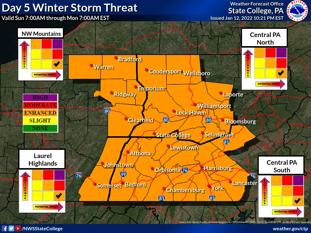
NWS isn’t predicting any snow totals at this point for the storm but it is expressing its “highest confidence for a plowable and high impact snowfall” for parts of Pennsylvania. Where all depends on the storm track, of course. One area NWS believes could receive a big amount of snow is the Interstate 81 corridor.
The Weather Channel is calling this event Winter Storm Lizzy. They’re the only ones that name winter storms.
And as of early Thursday morning, The Weather Channel is giving some predictions on snow totals for the area. In its forecast for Pottsville, TWC predicts between 5-8 inches of snow on Sunday night and another 1-3 inches on Monday during the day. So that’s anywhere between 6-11 inches, based on The Weather Channel forecast.
Accuweather is also giving some early numbers for the expected snowstorm. On Thursday morning, Accuweather has Pottsville receiving between 6-10 inches of snow between Sunday evening and Monday afternoon.
Now, for the ever-controversial weather models …
All we can report is that these weather models change, sometimes really quickly and drastically, so keep in mind that this potential storm is still 4 days away. And these same weather models just a few days ago had this storm way out over the ocean.
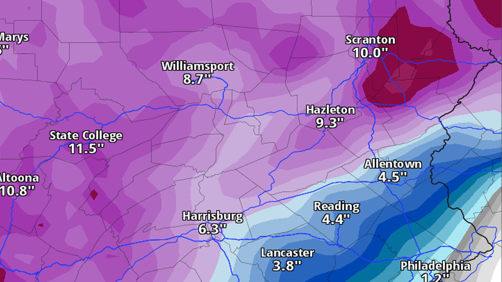
But now, the two most popular models, the American (GFS) and European (ECMWF) seem to be in agreement, at least, that’s it’s probably going to snow here.
Here’s a look at the latest GFS model run we had before publishing this article. It shows the accumulated snowfall between the time we collected the image through Monday night:
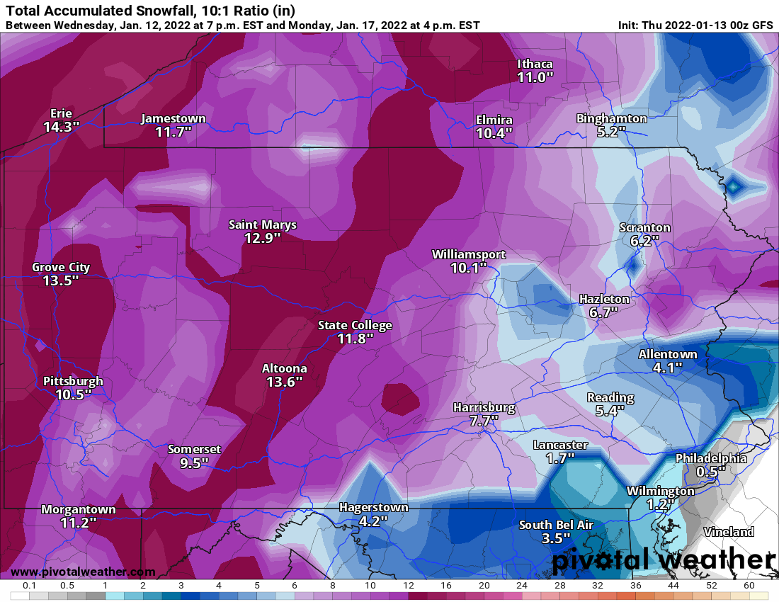
You can see that the GFS model shows us getting the lower end of the two weather stations’ predictions.
But the Euro model shows a slightly different picture, giving us closer to double-digit snow totals here in Schuylkill County.

Again, these are just models and aren’t necessarily forecasts. It’s important to know these things change and change often.
We’ll update the forecasts on this projected major winter storm through the end of the week.
Images: Pivotal Weather, National Weather Service
Subscribe to Coal Region Canary
Get email updates from Coal Region Canary by becoming a subscriber today. Just enter your email address below to get started!Support Coal Region Canary
Like our reporting and want to support truly local news in Schuylkill County? Your small donations help. For as little as $5, your contribution will allow us to cover more news that directly affects you. Consider donating today by hitting the big yellow button below ...












Gene Bonkoski
January 23, 2022 at 4:26 pm
Thanks for keeping us updated on the Skook news.
Canary Commenter
January 23, 2022 at 4:31 pm
You’re welcome but try to avoid using that phrase on our site. They’re the competition and don’t care for The Canary 😉
Sharon
January 2, 2024 at 3:44 pm
I agree with you Canary. I don’t like the word “Skook.” I think it takes the area down making it sound like hillbilly county.
I hope this storm misses us like others did. I’m not ready and never ready for big snows. I belong in a warm climate. 🙂 All I can think of is how many dead trees will be falling because of the Ash Borer and taking out the power once again. We lost power 13 times in Nov 2022, one time for almost 24 hours.