A tropical rain event is churning near the East Coast of the US with landfall possible in the next day or so. That storm could end up bringing heavy rain – and some flooding risk – to Schuylkill County this weekend.
Let’s take a closer look at some of the latest forecasts for a storm currently named Potential Tropical Cyclone 16.
Potential Tropical Cyclone 16 Briefing
Here’s a summary of information on Potential Tropical Cyclone 16:
- A developing tropical system is expected to impact the US East Coast, potentially spreading heavy rain, gusty winds, and rough seas from late this week to the weekend.
- The system formed a few hundred miles east of Florida, initially named Invest 99L, and was later referred to as Potential Tropical Cyclone 16 by the National Hurricane Center (NHC). Early satellite imagery indicates possible signs of tropical development.
- The storm is expected to strengthen as it moves towards the warm waters of the Gulf Stream along the Atlantic coast, with water temperatures ranging between 80-85°F.
- There is a high confidence among meteorologists that the system will develop into a tropical or subtropical storm, with the next names on the list being Ophelia and Phillippe.
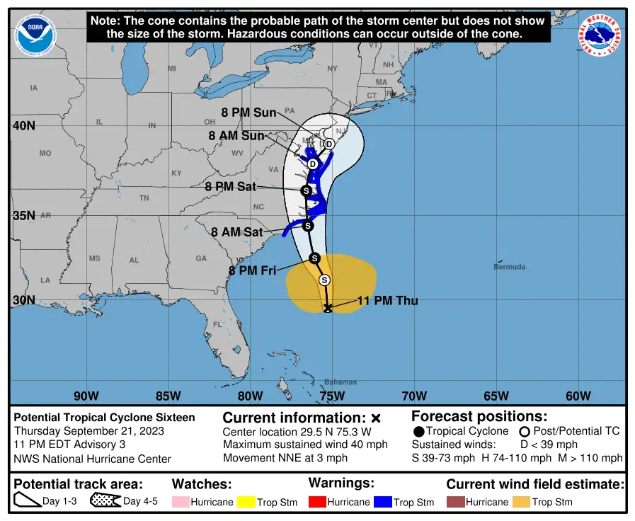
- A landfall is anticipated in eastern North Carolina on Saturday morning, and the storm might be named just before, during, or after this landfall.
- The storm’s track may cause it to follow the mid-Atlantic coast, possibly moving slightly inland. There’s a possibility it might move over eastern Virginia or the Delmarva Peninsula.
- The system’s exact track will determine the spread and intensity of the rain, with possibilities of it extending as far west as the Appalachians. If the storm moves more inland, its wind strength will decrease, but the rain might persist over the mid-Atlantic region.
Tropical Storm Warnings have already been posted for much of the East Coast from North Carolina extending into Maryland and Delaware.

How Might Potential Tropical Cyclone 16 Impact Schuylkill County?
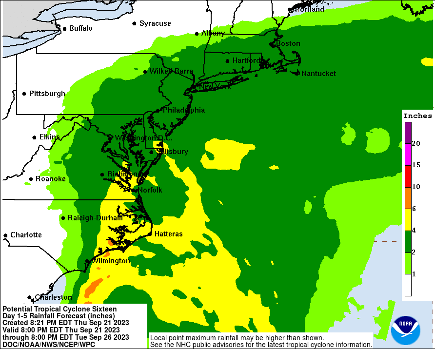
As we noted, this storm has the potential to drop some heavy rain on us here in Schuylkill County. Anywhere between 2-4 inches of rain (likely closer to 2 inches) could fall if the storm follows the path forecasters at National Hurricane Center currently see for it.
Schuylkill County could see the higher end of that rainfall total if the storm stalls or slows as it moves further inland throughout the weekend. The current 7-day forecast for Pottsville from National Weather Service in State College has the city getting, at most, 2.25 inches of rain between Saturday and Sunday.
As it stands now, expect the lower end of that potential. Still, 2 inches of rain is a lot of rain.
Here’s the current track of Potential Tropical Cyclone 16 from National Hurricane Center models:
Wind is not likely to be much of a factor with this storm. However, the NWS forecast for Pottsville does show wind gust potential this weekend at 30 mph on Saturday and 29 mph on Sunday. Expect steady wind between 15-20 mph both days.
The biggest risk for Schuylkill County from Potential Tropical Cyclone 16 definitely appears to be the rain.
This map from National Hurricane Center shows the rainfall forecast through Tuesday with Schuylkill County in the dark green (2-4 inches) zone:
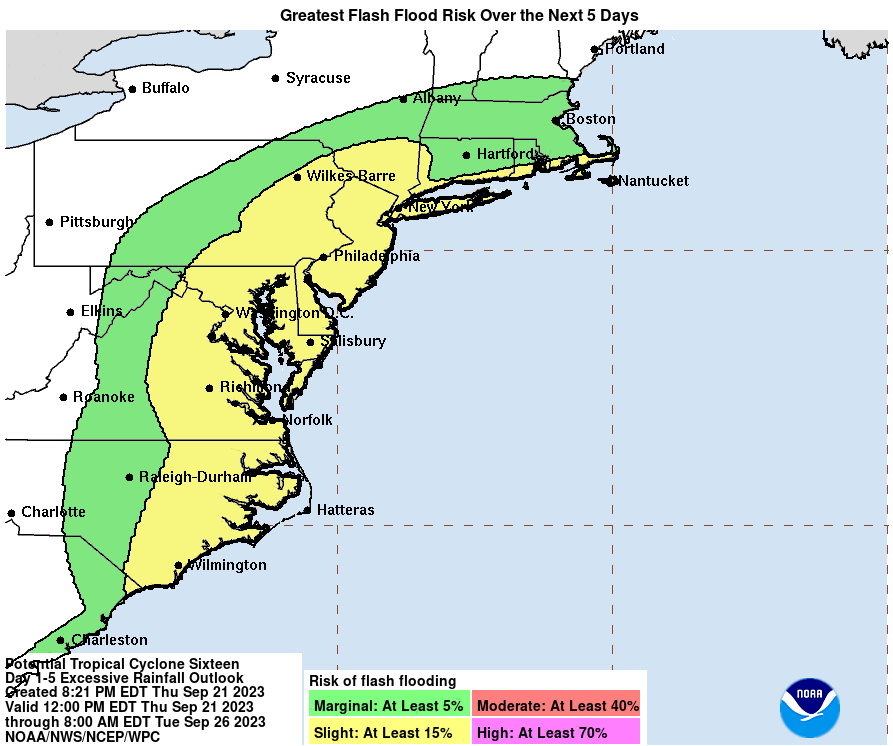
National Hurricane Center believes there is a Slight risk of flash flooding due to this storm’s rainfall here in Schuylkill County. Areas that typically flood in heavy rain events may want to take some precautions in the event this forecast holds over the next 24-36 hours:
What is a Potential Tropical Cyclone?
A “Potential Tropical Cyclone” (PTC) is a designation introduced by the National Hurricane Center (NHC) and other meteorological agencies to provide more timely warnings and forecasts for systems that are not yet a tropical cyclone but have a high chance of becoming one and pose a threat to land within 48 hours.
Before this designation was introduced, advisories would only be issued once a storm had achieved tropical depression status. However, this meant that there could be limited time between the designation of a tropical depression and its potential impact on land, which could limit the time available for preparations and warnings.
With the PTC designation, meteorologists can issue watches, warnings, and forecasts even before a system is formally classified as a tropical depression, tropical storm, or hurricane. This approach gives authorities and the public more time to prepare for potential impacts.
It’s worth noting that not every PTC will develop into a tropical cyclone, but the designation is used when there’s a high chance of such development and a potential threat to land.
Subscribe to Coal Region Canary
Get email updates from Coal Region Canary by becoming a subscriber today. Just enter your email address below to get started!Support Coal Region Canary
Like our reporting and want to support truly local news in Schuylkill County? Your small donations help. For as little as $5, your contribution will allow us to cover more news that directly affects you. Consider donating today by hitting the big yellow button below ...


