With the potential for an ice storm to hit Schuylkill County this week, we wondered, what makes an ice storm a “bad” ice storm?
We all know that ice storms can lead to treacherous travel conditions. But the effects of an ice storm can be even more life-threatening the more that ice continues to accumulate.
Power outages can last for days – or even weeks, sometimes – and tree limbs could break which might lead to property damage.
But how much ice is too much?
SPIA Index
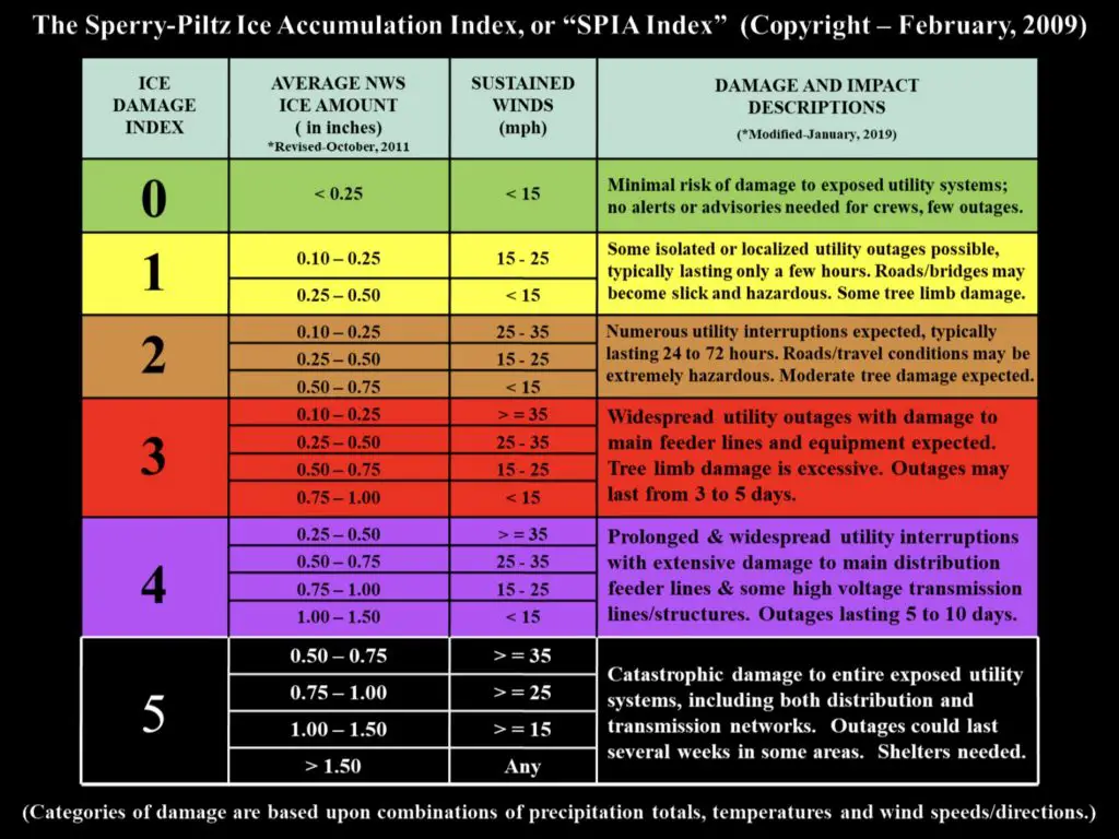
Luckily, there’s a chart to determine just how bad an ice storm can be and what to expect from the ice accumulations under varying circumstances. It’s called the SPIA Index, or Sperry-Plitz Ice Accumulation Index. It was developed by a meteorologist (Steven Piltz) and severe weather response expert (Sidney Sperry) who created this system that assigns a level of severity to ice storms similar to how tornadoes and hurricanes are rated.
The SPIA Index uses a scale of 0-5. And an ice storm gains intensity on this scale based on several factors:
- Ice accumulation
- Temperature
- Wind speed
SPIA Index was developed only back in 2009.
Ice Storm Damage Index
Let’s take a look at how ice storms are rated by the SPIA Index.
Here’s a handy chart Sperry and Piltz developed to help gauge when an ice storm increases in severity:

Image: SPIA-index.com
Photo: License via Depositphotos
Subscribe to Coal Region Canary
Get email updates from Coal Region Canary by becoming a subscriber today. Just enter your email address below to get started!Support Coal Region Canary
Like our reporting and want to support truly local news in Schuylkill County? Your small donations help. For as little as $5, your contribution will allow us to cover more news that directly affects you. Consider donating today by hitting the big yellow button below ...


