


The next round of wintry weather to hit Schuylkill County early this week may or may not be all that wintry.
Leading weather models, as of Sunday morning, are still at odds on whether this area will see a prolonged period of ice or rain starting Monday and extending into Tuesday.
One thing seems certain: it’s definitely going to do something. What that something is remains the unknown.
Ice or Rain Predicted for Monday-Tuesday Storm
The active wintry weather continues for another week, it seems. There’s already talk of a storm later this week, too. But first, the mess that’s due our way starting Monday and extending into Tuesday.
Let’s take a quick look at what the GFS and Euro models are suggesting.
GFS Model Run (Sunday Morning) for Snow-Ice-Rain Storm on Monday and Tuesday
The GFS run from Sunday morning suggests a prolonged period of plain rain in Schuylkill County following a short bit of frozen precip.
Here’s a look at what the GFS is showing starting Monday morning and carrying into the next day:

You can see the GFS predicting a short burst of freezing rain followed by a more prolonged period of moderate plain rain. Snow from this storm, as predicted by this GFS run, will stay to our north.
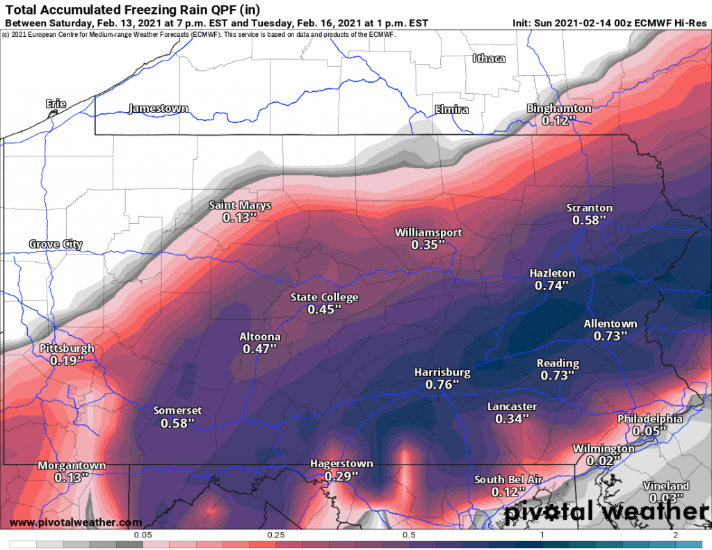
Euro Model Run (Sunday Morning) for Snow-Ice-Rain Storm on Monday and Tuesday
The Euro model run from Sunday morning paints a completely different picture for us here in Schuylkill County. Definitely, an icier picture.

As you can see, this Euro model run shows a prolonged period of moderate to heavy freezing rain glazing over Schuylkill County. Once again, like the GFS, snow is kept to our north. And on the Euro, the rain/ice line is right along the Schuylkill County border for a while.
If – and that’s a big IF – the Euro model proves to be accurate here, we’re talking about a considerable amount of ice from the freezing rain.
Here’s a look at the freezing rain accumulation from the Monday-Tuesday storm:

That’s close to an inch of freezing rain over much of the county IF this model run proves to be true.
Both models have the storm out of the area by Monday evening.
National Weather Service Forecast for Schuylkill County
For what it’s worth, National Weather Service sides with the wintry weather for now in Pottsville.
On Monday, NWS predicts snow, freezing rain and sleet during the afternoon with freezing rain and sleet to follow at night. Monday night, the frozen precipitation may mix with plain rain for a while before changing back to snow, sleet and freezing rain on Tuesday morning and then all snow on Tuesday afternoon.
While temperatures will hover around freezing much of the time while the storm’s passing through, it’ll be downright scary cold when it passes. A low temp of 13 is predicted in Pottsville on Tuesday night.
Model loops and images via Pivotal Weather