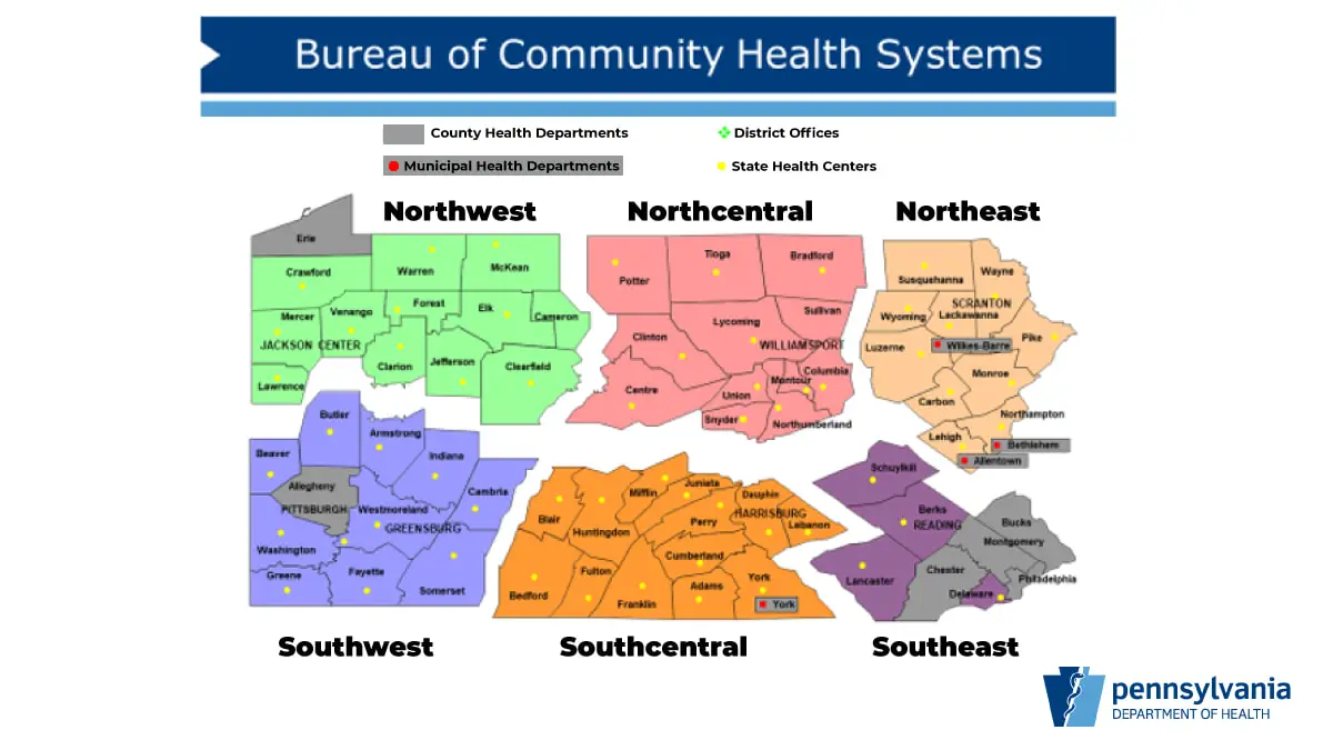
Pennsylvania’s health secretary admitted in a press conference Saturday that the map used to separate the state into health regions is not new.
In fact, it’s close to 60 years old!
That’s right … the map which determines what regions “re-open” when was drawn up in the 1960s. And, apparently, it’s never changed.

PA Health Secretary Rachel Levine said Saturday, “I don’t know the rationale” for drawing the lines where they’re drawn. But she added, “We feel these regions are best.”
So, on top of the fact that state health officials and Gov. Tom Wolf admit their decisions would largely be subjective — after swearing they’d be data-driven — we’re using a map that divides us into different regions that was crafted at a time when Pennsylvania looked a whole lot different.
Pennsylvania Using Map Drawn in the 1960s to Determine Regional Re-Opening

When this vintage map first got circulated on social media, a lot of people in Schuylkill County were pissed that we’d be included in the same region as Philadelphia.
Sure, we’ve got a New Philadelphia but beyond that, our similarities and connections are pretty hard to find.
This map puts Schuylkill County in the Southeast region. Counties in that region include:
- Philadelphia
- Delaware
- Chester
- Montgomery
- Bucks
- Lancaster
- Berks
- Schuylkill
Cue the music …
Wolf says his administration is looking at phasing two Pennsylvania regions from Red (where we all are now) to Yellow on May 8. Those are the Northwest and Northcentral. The Northcentral region includes two Schuylkill County neighbors, Northumberland and Columbia counties.
The criteria for going from Red to Yellow depends on a number of factors, including a confusing formula that, given two times to read it right from notes, Levine failed to get right during a Friday press conference.
And it won’t be a county-by-county opening. It’ll be regional, based on that dated map above. From what they’re saying, even if Schuylkill County hits its target low number of cases over a specific amount of time, we have to wait for Philadelphia County to catch up to us.
Suffice it to say, if the Wolf administration sticks to this, we could be looking at a long “quarantine” phase here in Schuylkill County.
It’s “impossible for me to give you a timeline,” Levine said in a recent press conference.
The Data Driven Decision to Re-Open Pennsylvania
Levine explained these regions are “health regions” in the state, based on health systems available. However, for Schuylkill County especially, this is far from accurate.
Think about it …
People in northern Schuylkill County aren’t likely to get specialized or advanced health care in the southeast region. They’re going to Danville.
For our neighbors in the western stretch of Schuylkill County, they’re more likely to seek that kind of care in Hershey.
People from Pottsville and points east and south, they’re likely to visit places like Lehigh County. Lehigh is in the Northeast region on this 1960s map. The Northeast? Lehigh County is more southeast than Schuylkill but included in the Northeast.
So, why are we in the Southeast? And why are we using a map from the 1960s?
Remember, the decision to “re-open” Pennsylvania will be data driven, according to our Governor.
What data is the state consulting to make this call?
FOR MORE …
- Coronavirus in Schuylkill County
- Martial Law vs. Marshal Law – Know the Difference
- 19 Different Hand Washing Songs for the Coronavirus Outbreak
- Our 2 Week Food Supply List is More Essential Than Ever
Subscribe to Coal Region Canary
Get email updates from Coal Region Canary by becoming a subscriber today. Just enter your email address below to get started!Support Coal Region Canary
Like our reporting and want to support truly local news in Schuylkill County? Your small donations help. For as little as $5, your contribution will allow us to cover more news that directly affects you. Consider donating today by hitting the big yellow button below ...


