Here’s the latest information on the big winter storm headed for Schuylkill County this weekend and into next week. It’s a storm we’re dubbing SnOmicron.
The Weather Channel is calling this storm Izzy.
And based on the latest forecasts, here’s what we know about this big winter storm:
Big Winter Storm for Schuylkill County – Latest Info
- Start time: Sunday evening
- End time: Monday afternoon
- Precip type(s): Snow, freezing rain, rain
- Travel disruption: Likely
- School delays/closings: Likely (Monday, Tuesday)
- Snow total: 3-10 inches
- Ice total: Up to .15 inch
Weather Models for Big Winter Storm on Jan. 16-17, 2022
Here’s a look at some weather model forecasts for the big storm headed our way on Sunday into Monday.
GFS Model
First, let’s take a look at the GFS model showing the forecast through Monday by precipitation type:

You can see from that loop, the GFS is showing more of a mixed precipitation and then rain, especially at the tail end of the storm.
That translates into a lower snow total from the GFS model. Again, these models should be seen as just that, not an actual forecast.

If this model holds true, that would keep snow totals in Schuylkill County between 3-6 inches.
However, if the storm moves east just a little bit, this model would show us getting higher snow totals as the rain-snow line moves accordingly.
Euro Model
Now, let’s check the Euro model and see how it compares. And when you see this, you’ll get an idea of what might happen if the storm pulls to the east just a tad.
Here’s the precip loop through Monday on the Euro model:
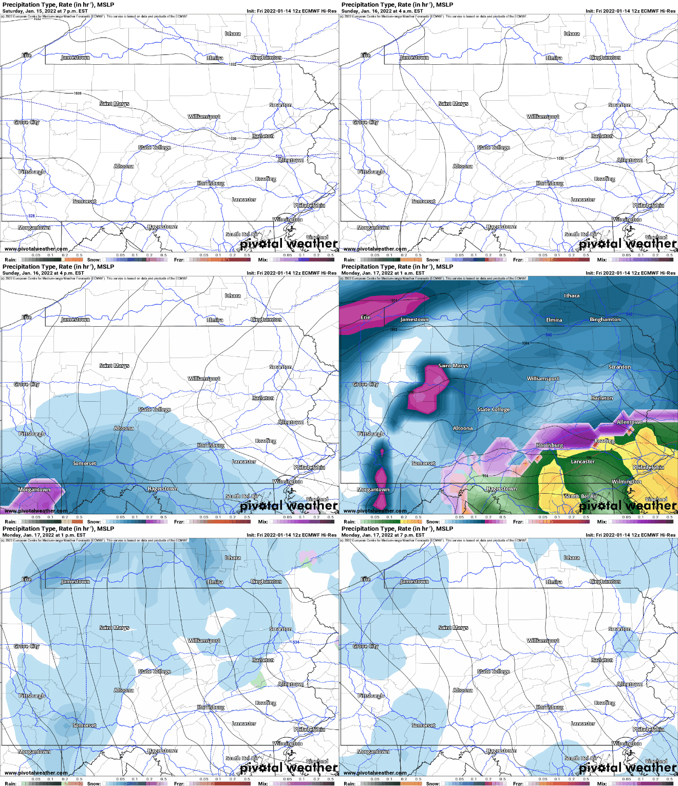
You see less of a change to rain or freezing rain in that run.
And that translates to forecasted higher snow totals, as evidenced here:
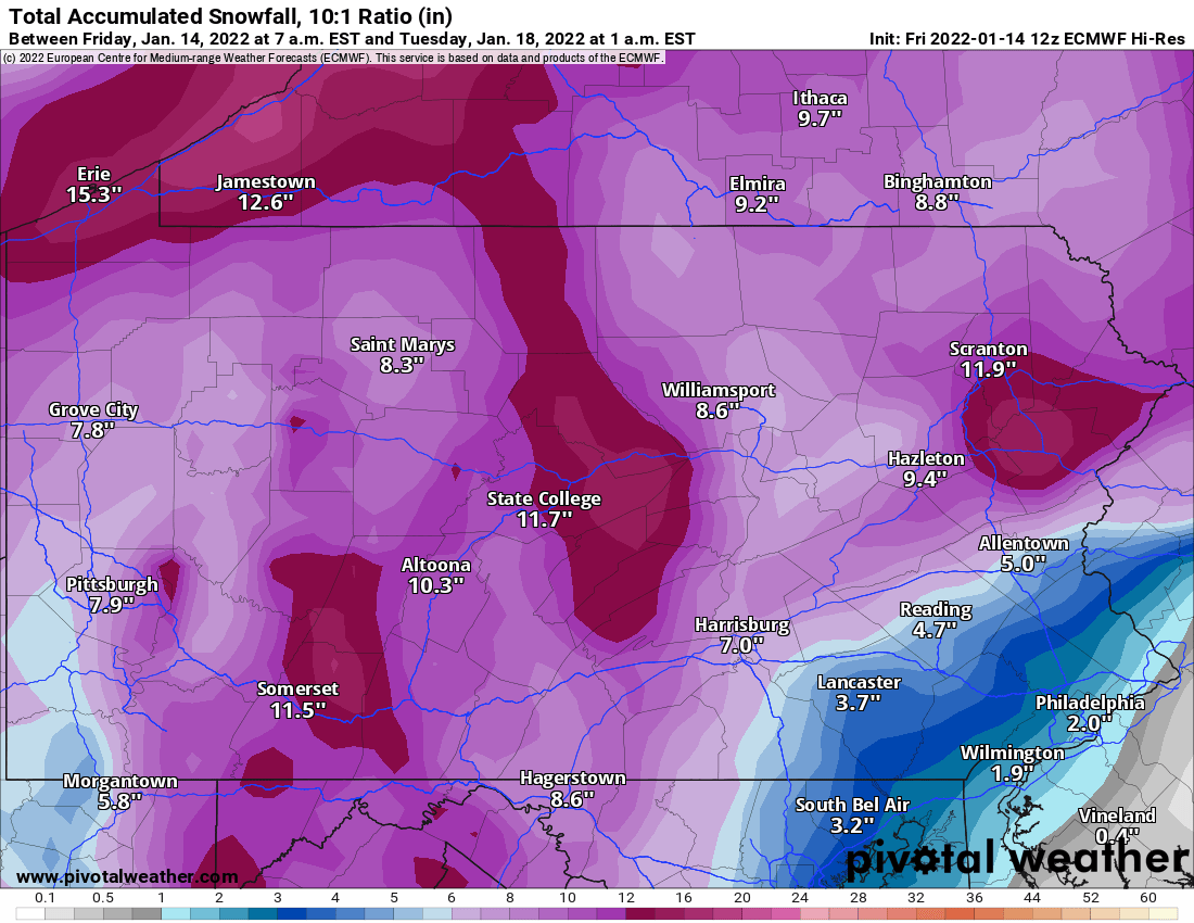
This map shows Schuylkill County more in the 8-11 inches of snow range.
So, now that you’ve seen the models, here’s a look at how they’re being translated by meteorologists:
National Weather Service
National Weather Service is forecasting for a smaller snow event this weekend. Right now, they’re sure it’s going to snow but totals are very low from them. As of 3 p.m. Friday, NWS is predicting about 2-4 inches of snow for Pottsville.
This forecast is betting on a change to rain on Monday that mixes with snow at times. The forecast high on Monday is 36 degrees.
The Weather Channel
The Weather Channel is a bit more liberal (big surprise) with its snowfall forecast for Pottsville. Most of that will fall Sunday night, they say. As of 3 p.m. Friday, TWC is calling for between 3-6 inches of snow. Again, a change to rain at some point on Monday is expected to keep snow totals down a bit. Sleet and freezing rain is possible, too.
Accuweather
Accuweather is still holding out hope, perhaps, that this is a big snow event for us here in Schuylkill County. Also as of 3 p.m. Friday, they’re predicting between 6-10 inches of snow for Pottsville with a small ice accretion, too.
Fannock Weather Forecast
Local weather enthusiast Ryan Fannock, whom a lot of people claim to rely on solely for their weather updates in Schuylkill County, at last check, wasn’t confident enough to make a prediction on snow totals here. He’s seeing the insecurity among the other forecasters, surely, and doesn’t want to make the call just yet.
Subscribe to Coal Region Canary
Get email updates from Coal Region Canary by becoming a subscriber today. Just enter your email address below to get started!Support Coal Region Canary
Like our reporting and want to support truly local news in Schuylkill County? Your small donations help. For as little as $5, your contribution will allow us to cover more news that directly affects you. Consider donating today by hitting the big yellow button below ...


